Файл:Earth-DSCOVR-20150706-IFV.jpg
Инъет луись файл (1788 × 1756 пиксель, файллэн быдӟалаез: 646 Кб, MIME-типез: image/jpeg)
Cведения об этом файле находятся на Викискладе?, хранилище изображений и мультимедиа для использования во всех проектах Фонда Викимедиа
|
Вакчияк пуштросэз:
| Кылсуред |
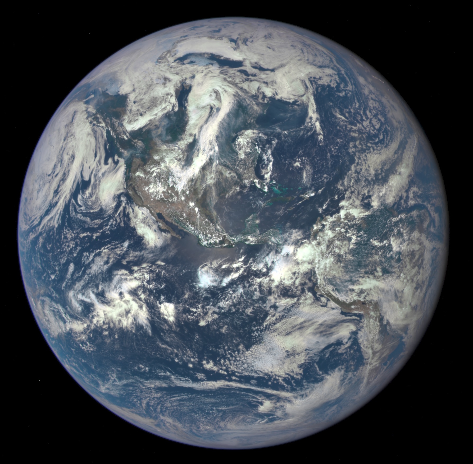
English: NASA Captures "EPIC" Earth Image
A NASA camera on the Deep Space Climate Observatory satellite has returned its first view of the entire sunlit side of Earth from nearly one million miles away. This color image of Earth was taken by NASA’s Earth Polychromatic Imaging Camera (EPIC), a four megapixel CCD camera and telescope. The image was generated by combining three separate images to create a photographic-quality image. The camera takes a series of 10 images using different narrowband filters -- from ultraviolet to near infrared -- to produce a variety of science products. The red, green and blue channel images are used in these color images. The image was taken July 6, 2015, showing North and Central America. The central turquoise areas are shallow seas around the Caribbean islands. This Earth image shows the effects of sunlight scattered by air molecules, giving the image a characteristic bluish tint. The EPIC team is working to remove this atmospheric effect from subsequent images. Once the instrument begins regular data acquisition, EPIC will provide a daily series of Earth images allowing for the first time study of daily variations over the entire globe. These images, available 12 to 36 hours after they are acquired, will be posted to a dedicated web page by September 2015. The primary objective of DSCOVR, a partnership between NASA, the National Oceanic and Atmospheric Administration (NOAA) and the U.S. Air Force, is to maintain the nation’s real-time solar wind monitoring capabilities, which are critical to the accuracy and lead time of space weather alerts and forecasts from NOAA. |
| Дырвадес | Снято: 6 Пӧсьтолэзе 2015, 19:01:11 |
| Кылдонэз | http://www.nasa.gov/image-feature/nasa-captures-epic-earth-image (image link); see also https://epic.gsfc.nasa.gov/?date=2015-07-06 image #3. |
| Автор | NASA |
| Другие версии |
|


Лицензировани
| Этот файл находится в общественном достоянии (англ. public domain), так как он был создан NASA (Национальным управлением по аэронавтике и исследованию космического пространства). Политика авторского права NASA гласит, что «Материал NASA не защищается авторским правом, если не указано иное». (См. Template:PD-USGov, страницу политики авторского права NASA или политику использования изображений JPL.) | ||
 |
Предупреждения:
|
Файллэн историез
Файллэсь азьвыл кыӵе луэмзэ учкон понна, дырвадесэз/дырез возьматӥсь кнопкаез зӥбе.
| Дырвадес/дыр | Пичиятэм тус | Быдӟалаез | Юзчи | Веран-вазён | |
|---|---|---|---|---|---|
| алиез | 11:18, 21 Пӧсьтолэзе 2015 | | 1788 × 1756 (646 Кб) | JorisvS | crop a bit |
| 16:01, 20 Пӧсьтолэзе 2015 |  | 2048 × 2048 (1,49 Мб) | Drbogdan | User created page with UploadWizard |
Файлэз уже кутон
Та файлэз уже кутӥсь бамъёс ӧвӧл.
Файлэз оглом уже кутон
Та файлэз ужазы куто мукетъёсыз викиос:
- Уже кутон ca.wikipedia.org
- Уже кутон en.wikipedia.org
- Уже кутон en.wikiquote.org
- Уже кутон en.wikiversity.org
- Уже кутон es.wikipedia.org
- Уже кутон fr.wikipedia.org
- Уже кутон gl.wikipedia.org
- Уже кутон he.wikipedia.org
- Уже кутон incubator.wikimedia.org
- Уже кутон it.wikipedia.org
- Уже кутон ja.wikipedia.org
- Уже кутон pl.wikipedia.org
- Уже кутон ru.wikipedia.org
- Уже кутон ru.wiktionary.org
- Уже кутон tr.wikiquote.org
- Уже кутон uk.wikipedia.org
- Уже кутон www.wikidata.org
- Уже кутон wuu.wikipedia.org